Hawaii: Ahupua’a system
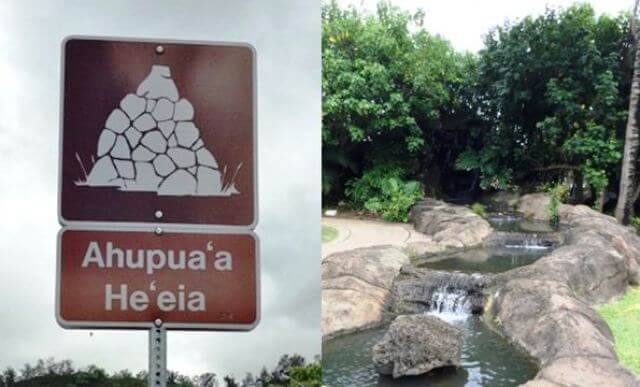
Have you noticed on your way to the Polynesian Cultural Center that there are signs along the Hawaii that look like this? These signs signify a delineation of land called the Ahupua’a system.
Our village is set up as a mini Ahupua’a, or land division, to demonstrate the diversity of land use from the steep mountain ridges to the ocean below. In the days of King Kamehameha I, land was divided up amongst ohana (family) units. Each division included a portion of the central mountain region, through the verdant valley floor, and down to the ocean shore and even into the seawater, past the reef. This region of land was designed to be self-sustainable, supplying ohana with access to all levels of island resources, including fish and other ocean creatures, fresh water, fertile areas to farm, native animals for hunting, and other island resources.
Look for the waterfall, which is situated between the Chief’s House and the Men’s Eating House. It represents the clear water that falls from the verdant ridge tops to the plains section. Now look for the taro patch. Villagers planted crops along the river before it was channeled through the village and down to shoreline fishponds, exiting into the ocean.
Our villagers will be happy to demonstrate how these various stations created a balanced ecosystem that supported and nourished early villages.